GIS Showdown! Comparing Google Maps, OpenStreetMap, and More
TL;DR
This report compares GIS systems like Google Maps, OpenStreetMap, ArcGIS, FME, and Mapbox based on cost, scalability, and data quality. OpenStreetMap is ideal for budget projects, ArcGIS for data-intensive tasks, and Mapbox for startups needing custom maps.

This report explores different GIS systems and analyzes them on a comparative basis using criteria such as cost, scalability, data quality, and reliability. Our considerations include systems that are accessible via an API and are widely recognized in the industry.
GIS Systems In Consideration
Google Maps API
Google Maps is an industry leader. They offer a feature-rich experience but stay relatively open to an in-home or light user through a free monthly usage allowance.
Here are some of their key features:
- Maps: High-resolution street view, customizable map tiles, and detailed aerial imagery.
- Routes: Advanced route computation, real-time traffic updates, and route optimization for efficiency.
- Places: Comprehensive place data, including address validation, place/address autocomplete, detailed geocoding and geolocation, nearby search, text search, and more.
- Environment: Environmental data services, including air quality monitoring, pollen levels, and solar energy potential.
https://mapsplatform.google.com/pricing/
OpenStreetMaps
OpenStreetMap is an open-source, community-driven mapping tool that relies on frequent updates from volunteers. They have a near-unlimited supply of information as they allow users to tag and map anything ranging from funny street signs to fire hydrants in your city.
Here are some of their key features:
- Open Source: Completely free and open-source data, maintained by a large, active community of contributors.
- Unique Variety of Tags: Users can tag an extensive range of features resulting in a vast and diverse dataset.
- Customizable: Fully customizable maps, allow users to create, style, and deploy maps tailored to any specific purpose. OSM is a favourite among researchers and data analysts for its flexibility and depth of data.
https://wiki.openstreetmap.org/wiki/Map_features
FME
Feature Manipulation Engine (FME) is a unique entry on this list, seeming to be a fan favourite among internet users. FME has no standard pricing table, choosing to customize their solution to your needs. While this works for organizations, it might be a barrier to at-home use.
Here are some of their key features:
- Data Integration: Supports a vast array of data formats, making it a powerful tool for integrating different types of data.
- Geospatial Focus: Specializes in transforming and automating geospatial data workflows, ensuring seamless data processing and analysis.
- Support: Provides robust support for data validation and quality control, with custom solution packages and flexible pricing to meet specific organizational needs.
https://fme.safe.com/fme-in-action/data-types/gis-location-intelligence/
ArcGIS
ArcGIS is a comprehensive system striving to be a player for any use-case of a GIS system. They offer a robust suite of tools for mapping and spatial analysis. Like FME, ArcGIS seems better geared towards an organizational user, only providing limited features on their free tier not intended for commercial use.
Here are some of their key features:
- Mapping & Visualization: Create and share interactive maps, 3D visualizations, and dynamic map layers.
- Spatial Analysis: Advanced spatial analytics, including pattern detection, spatial statistics, and predictive modelling.
- Data Management: Manage and integrate various types of spatial data, with robust editing and versioning capabilities.
- Collaboration & Sharing: Allows the sharing of maps and data with colleagues or the public.
Mapbox
Mapbox is a versatile mapping platform known for its flexibility and developer-friendly approach. It provides powerful tools for creating custom maps and applications, making it a popular choice for technical developers who want the freedom to manipulate each facet of their product.
Here are some of their key features:
- Custom Maps: Highly customizable map styles and designs, with options for 2D and 3D maps.
- Navigation: Turn-by-turn navigation, real-time traffic updates, and route optimization.
- Geocoding & Search: Accurate geocoding, address validation, and location search capabilities.
- Real-time Data: Integrate real-time data sources for dynamic and interactive map experiences.
https://www.mapbox.com/pricing
Pricing Comparison
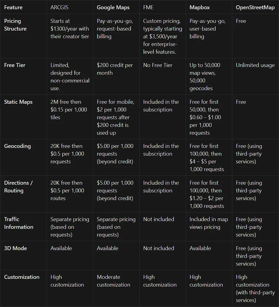
Data from:
https://relevant.software/blog/choosing-a-map-amapbox-google-maps-openstreetmap/
https://location.arcgis.com/pricing/#basemaps
https://www.trustradius.com/products/fme/reviews#overview
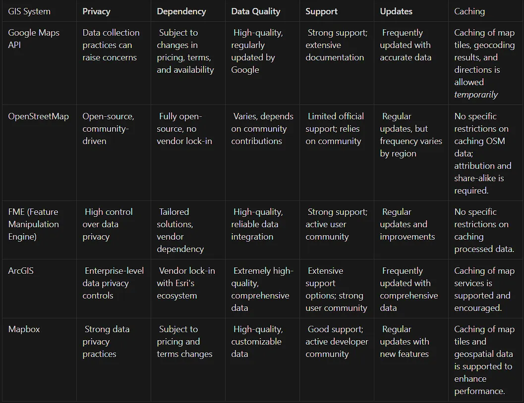
Scalability & Usage Considerations
When choosing a GIS system for your project or business, considering future limitations is a key step. While many of these services offer free tiers to get you comfortable with their tools, success can come at a price. Let’s take a look at the winners in each forward-looking category as well as the justification behind the choice.
Cost
Winner: OpenStreetMap
Justification: Completely free and open-source, with no usage fees.
Usage Limitations
Winner: OpenStreetMap
Justification: No limitations on usage, offering unrestricted access to data and tools.
Data Quality
Winner: ArcGIS
Justification: Provides extremely high-quality, comprehensive data that is regularly updated.
Ease of Integration
Winners: Google Maps API / Mapbox
Justification: Designed for seamless and straightforward integration with various platforms and applications.
Customization
Winner: OpenStreetMap
Justification: Highly customizable due to its open-source nature and extensive tagging system.
Support & Community
Winners: ArcGIS / Google Maps API (Strong support)
Justification: Both offer extensive support options and strong user communities.
Scalability
Winners: ArcGIS / Google Maps API / Mapbox (Highly scalable)
Justification: All are highly scalable, making them suitable for enterprise-level applications.
Overall Winners For Scalability & Usage: OpenStreetMaps & ArcGIS
Top Concerns
Recommendations Based on the Use Case
Startups
👉 Mapbox: developer-friendly platform with flexible pricing, making it ideal for startups that need customizable maps and real-time data integration without a high initial cost.
Budget Pick
👉 OpenStreetMap: completely free and open-source, providing unlimited access to a vast array of data and customization options, perfect for projects with tight budgets.
Niche Requirements
👉 FME: excels in transforming and integrating various data formats, making it suitable for specialized projects that require advanced data manipulation and custom workflows.
Data-Intensive Projects
👉 ArcGIS: advanced spatial analysis and data management capabilities, making it well-suited for projects that involve complex datasets and require detailed geospatial insights.
Enterprise-Level Solutions
👉 Google Maps: provides high-quality data, ease of integration, and advanced features such as real-time traffic and route optimization, suitable for large enterprises that require dependable and scalable GIS capabilities.
Conclusion
All of these tools rightfully have their place in the GIS market space, but as we’ve learned, each excels for different reasons. The key to choosing the right tool begins with understanding your specific needs and requirements. It is essential to clearly define your use case, and then cater your choice with it at the center. Consider factors such as cost, scalability, data quality, ease of integration, and the level of customization required for your project. By thoroughly evaluating these aspects, you can make an informed decision that aligns with your objectives and maximizes the benefits of the chosen GIS system.
References
ArcGIS. (2024, June 28). GIS Mapping Software, Location Intelligence & Spatial Analytics | Esri. https://www.esri.com/en-us/arcgis/geospatial-platform/overview?rsource=https://www.esri.com/en-us/arcgis/about-arcgis/overview
Dziuba, A. (2024, July 23). Choosing a map API for your next app: Mapbox, Google maps, or OpenStreetMap? Relevant Software. https://relevant.software/blog/choosing-a-map-amapbox-google-maps-openstreetmap/
FME reviews & ratings 2024. (n.d.). Just a moment… https://www.trustradius.com/products/fme/reviews#overview
Geospatial and GIS data. (2023, April 9). FME by Safe Software. https://fme.safe.com/fme-in-action/data-types/gis-location-intelligence/
Google maps security concerns. (2017, December 29). SCIRP. https://www.scirp.org/journal/paperinformation?paperid=81614
Map features. (n.d.). OpenStreetMap Wiki. Retrieved July 28, 2024, from https://wiki.openstreetmap.org/wiki/Map_features
Platform pricing & API costs. (n.d.). Google Maps Platform. https://mapsplatform.google.com/pricing/
Pricing. (n.d.). ArcGIS Location Platform. https://location.arcgis.com/pricing/#basemaps
Mapbox pricing. (2024, 27). Mapbox | Maps, Navigation, Search, and Data. https://www.mapbox.com/pricing
Google. (n.d.). Privacy & Terms. Retrieved July 26, 2024, from https://policies.google.com/privacy
Google Cloud. (n.d.). Maps Platform Pricing. Retrieved July 26, 2024, from https://cloud.google.com/maps-platform/pricing
Google Developers. (n.d.). Google Maps Platform Documentation. Retrieved July 26, 2024, from https://developers.google.com/maps/documentation
Google Developers. (n.d.). Google Maps Platform Support. Retrieved July 26, 2024, from https://developers.google.com/maps/support
Google Developers. (n.d.). Google Maps API Updates. Retrieved July 26, 2024, from https://developers.google.com/maps/documentation/updates
OpenStreetMap Foundation. (n.d.). Privacy Policy. Retrieved July 26, 2024, from https://wiki.osmfoundation.org/wiki/Privacy_Policy
OpenStreetMap Wiki. (n.d.). Data. Retrieved July 26, 2024, from https://wiki.openstreetmap.org/wiki/Data
OpenStreetMap Wiki. (n.d.). Quality Assurance. Retrieved July 26, 2024, from https://wiki.openstreetmap.org/wiki/Quality_Assurance
OpenStreetMap Wiki. (n.d.). Contact Channels. Retrieved July 26, 2024, from https://wiki.openstreetmap.org/wiki/Contact_channels
Humanitarian OSM Team. (2023). Data Quality Approach. OpenStreetMap Wiki. Retrieved July 26, 2024, from https://wiki.openstreetmap.org/wiki/Data_Quality_Approach
Safe Software. (n.d.). Privacy Policy. Retrieved July 27, 2024, from https://www.safe.com/privacy-policy/
Safe Software. (n.d.). Licensing Options. Retrieved July 27, 2024, from https://www.safe.com/pricing/licensing-options/
Safe Software. (n.d.). FME Desktop: Data Integration. Retrieved July 27, 2024, from https://www.safe.com/fme/fme-desktop/data-integration/
Safe Software. (n.d.). Support. Retrieved July 27, 2024, from https://www.safe.com/support/
Safe Software. (n.d.). What’s New. Retrieved July 27, 2024, from https://www.safe.com/whats-new/
Esri. (n.d.). Privacy Overview. Retrieved July 27, 2024, from https://www.esri.com/en-us/privacy/overview
Esri. (n.d.). Legal Overview. Retrieved July 27, 2024, from https://www.esri.com/en-us/legal/overview
Esri. (n.d.). ArcGIS Living Atlas: Data. Retrieved July 27, 2024, from https://www.esri.com/en-us/arcgis/products/arcgis-living-atlas/data
Esri. (n.d.). Support. Retrieved July 27, 2024, from https://support.esri.com/en/
Esri. (n.d.). What’s New in ArcGIS. Retrieved July 27, 2024, from https://www.esri.com/en-us/arcgis/whats-new/overview
Mapbox. (n.d.). Privacy Policy. Retrieved July 28, 2024, from https://www.mapbox.com/legal/privacy
Mapbox. (n.d.). Pricing. Retrieved July 28, 2024, from https://www.mapbox.com/pricing
Mapbox. (n.d.). Data Sources. Retrieved July 28, 2024, from https://www.mapbox.com/maps/data-sources
Mapbox. (n.d.). Support. Retrieved July 28, 2024, from https://support.mapbox.com/hc/en-us
Mapbox. (n.d.). Changelog. Retrieved July 28, 2024, from https://www.mapbox.com/changelog
This blog is also published on ourMedium page